Posted May 2, 2023
(Editor’s note: UW-River Falls student journalists enrolled in JOUR 111, Introduction to Data Journalism, spent part of spring semester 2023 studying dams in western Wisconsin. This story and and an accompanying database, derived from the state Department of Natural Resources registry of dams, are the result of their work.)
A trip to River Falls makes apparent the close relationship western Wisconsinites have with their bodies of water. One can stop at the Kinni Café for coffee and breakfast or in one of the many bars downtown for a craft beer from Rush River Brewing, both named after rivers in the area.
These bodies of water are a source of scenery and leisure. Several hundred of them also are sites for dams. And for Michael Rogney, managing these dams — including 62 in Pepin County, 93 in Pierce County, 94 in Polk County and 67 in St. Croix County — is a full-time job at the Department of Natural Resources. And that’s just the dams that the DNR is aware of.
The Wisconsin Repository of Dams lists more than 4,800 dams statewide.
But according to Rogney, who is a DNR water management engineer based in Eau Claire, the number of unregistered dams is potentially very large. The management of western Wisconsin’s bodies of water is no easy task, and that’s why the state oversees the operation and upkeep of a large number of dams.
Small and large
Between Polk, Pierce, St.Croix and Pepin counties, there are a total of 316 dams recorded in the Wisconsin Repository of Dams. Of those, 202 are classified as “small” dams, and 64 are “large” dams.
The remaining 50 dams are currently not classified as either small or large. Many of the dams that are not classified have been removed but are still listed in the database.
According to the Wisconsin DNR, for a dam to be classified as large, it must have “a structural height of over 6 feet and impounds 50 acre–feet or more, or has a structural height of 25 feet or more and impounds more than 15 acre–feet.” Any dam that does not meet those criteria is considered a small dam.
The risk of dams
Most small dams are listed with a “low” hazard rating, while the majority of those with either a “high” or “significant” hazard rating are large dams, though it is important to know that not all large dams have those ratings. A few of the small dams in the counties have those higher hazard ratings as well.
All dams entered into the Wisconsin DNR database receive a hazard rating based on their potential danger if they were to fail. These ratings are based on the threat to human life or property, or to the environment. Dams with a “low” rating pose no probable threat to human life or property. Dams rated as “significant” pose no probable risk to human life but can affect the environment and cause economic loss. Many significant-risk dams are located in rural and agricultural areas, as a breach endangers the land, not human life. Lastly, dams labeled as “high” threaten humans and may result in loss of life if breached.
According to the Wisconsin DNR, there are 288 low-risk dams, 12 significant-risk dams, and 16 high-risk” dams in Pepin, Pierce, Polk and St.Croix counties. All 16 high-risk dams are over six feet in height and are classified as large dams. Of the 16 high-risk dams, St.Croix County has 10, Polk has four, Pierce has two and Pepin has zero. The location of high-risk dams coincides heavily with population size, as St.Croix County has a population over double that of Polk and six more high-risk dams.
Most dams privately owned
At least two-thirds of the 316 dams — a total of 210 — in Polk, St. Croix, Pierce and Pepin counties are privately owned. About 19% of the dams are owned by government entities, while 47 dams in the DNR registry do not have ownership data.
According to the Wisconsin DNR, when a property with a dam is purchased a dam transfer is required by law. Without one, the real estate transaction could be voided.
For these types of transactions, both the seller and the buyer of the property on which a dam is located must cooperate to complete a dam transfer application. An inspection is required prior to transferring the property and dam, as well as a description of any repairs needed to bring the dam into compliance with safety standards. Finally, the buyer must also show financial capability to maintain the dam for a minimum of 10 years.
Four of the dams in Polk, St. Croix and Pierce counties are licensed by the Federal Energy Regulatory Commission. FERC is an independent agency that regulates the interstate transmission of natural gas, oil, and electricity. The commission also regulates hydropower projects like dams, including the Junction Falls dam on the Kinnickinnic River in River Falls.
The city of River Falls owns both the Junction Falls dam as well as the Powell Falls dam, although the latter one no longer is used to generate power.
The “Free the Kinni” citizens movement has long advocated for removing both of the dams and restoring the free flow of the Kinnickinnic River. The River Falls City Council in 2018 voted in favor of removing both dams. In February 2022, FERC decommissioned the Powell Falls dam.
The city now is awaiting word on whether it could qualify for up to $10 million in funding from the U.S. Army Corps of Engineers to remove both dams.
A history of dams
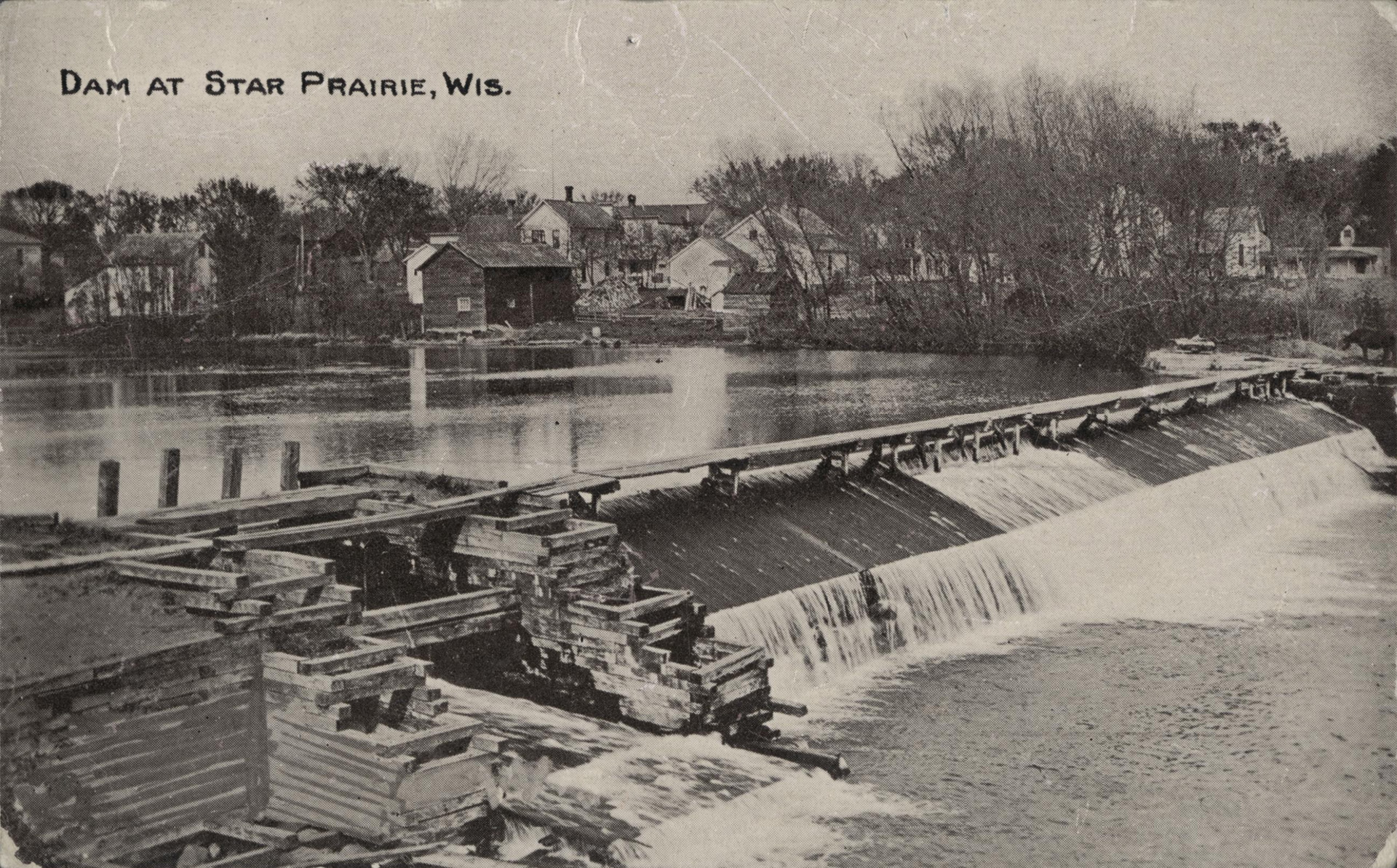
The wooden dam at Star Prairie in St. Croix County, pictured about 1911 on a postcard. (Photo from UW–Digitized Collections)
About 20 of the dams in the four counties listed in the DNR’s registry were constructed in the 19th century. Almost all have long since been removed. Two of the oldest dams were built in 1850 in Pierce County, according to the DNR. One was on the Trimbelle River, south of the unincorporated village of Trimbelle, and the other was north of Martell on the Rush River.
According to the Pierce County Historical Association, the dams were originally built by the first white settlers. During the creation of the new settlement, Pierce County was referred to as Elizabeth Township. It wasn’t until 1853 that Pierce County got its current name after the 14th U.S. president, Franklin Pierce. New settlers were specialists in jobs ranging from teachers and ministers to woodworkers and retailers. The dam building resulted from grist millers planning to create mill ponds that could be used to turn a water wheel for power. This would be used to the benefit of the settlement and its workers.
The DNR registry also shows that a dam was built in 1850 on the Apple River at Somerset. However, that dam actually may have been built a number of years later when brothers Samuel and Hud Harriman settled along the river and established the village, according to John T. Rivard’s 1956 Somerset history, Triple Centennial Jubilee Souvenir Book. The brothers built a grist mill and dam. They also built a general store and platted streets for Somerset.
In a state with a large number of lakes and rivers, it is often necessary to build dams in order to make possible the building of communities. On a smaller scale, owners of private property often build dams when it is advantageous to their goals. Dams have been built in western Wisconsin since the mid-19th century and they have been an important part of both the ecosystem and the economy of the area ever since.
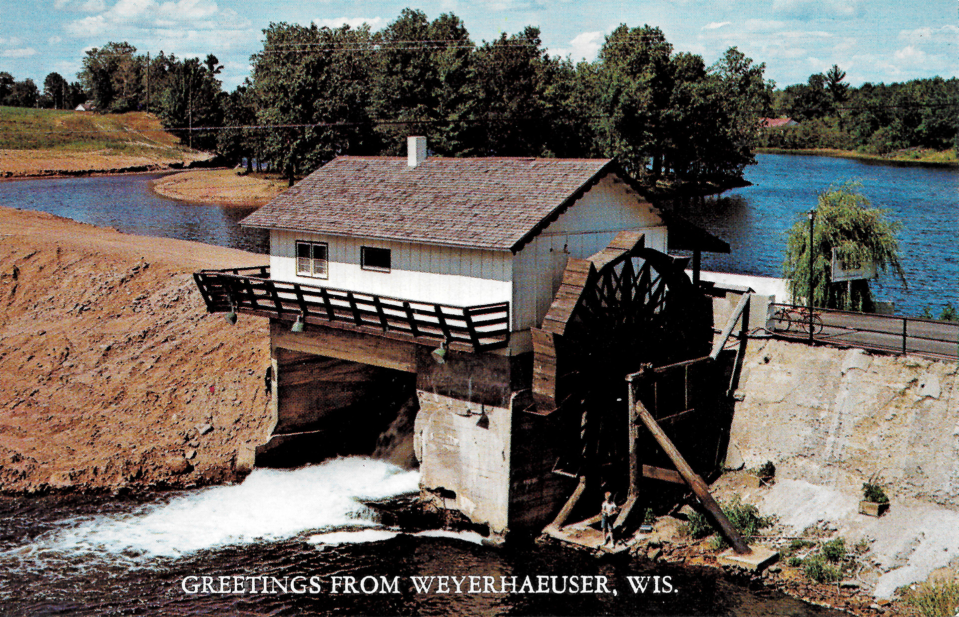
A postcard — incorrectly labeled “Greetings from Weyerhaeuser, Wis.” — shows the former Woodley Dam on the Apple River north of Amery in Polk County. Damaged in a 2001 flood, the dam soon became the focus of removal efforts. The generator house and water wheel were demolished in 2003. Officially known as the Ridler Dam, the rest of the structure was removed in 2009. The postcard was created by Emil Fremming of Chetek, probably in the 1950s or 1960s. Weyerhaeuser is a village in Rusk County, about 50 miles to the east of the Woodley Dam’s location.
The article may be found online at https://uwrfjournalism.org/2023/05/hundreds-of-dams/.